


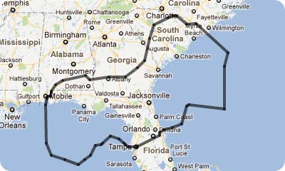
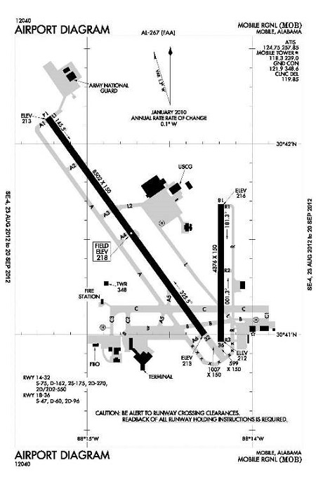
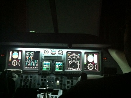
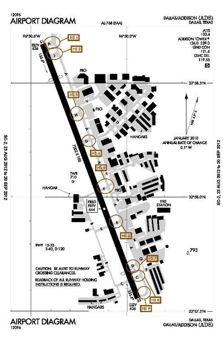
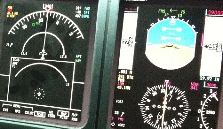
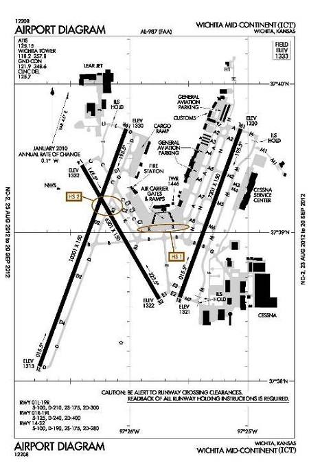
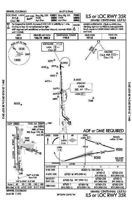
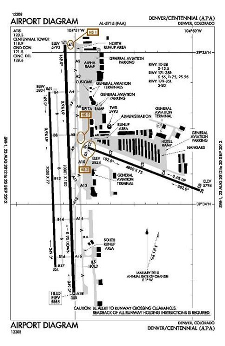
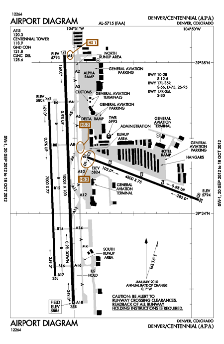
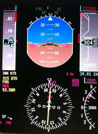
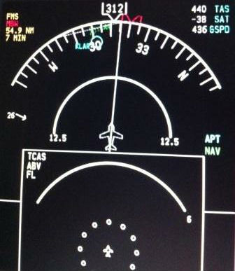
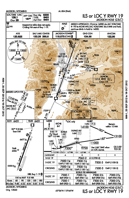
(Original thread started on 09-06-12 by Eric Tomlin) Introduction I thought it might be interesting to start a mini-log of my Friday night flights across the United States. As some of you may know, I have a friend that comes over nearly each and every Friday night to fly the simulator and depending on interests and VATSIM coverage, we've flown all over the US as a crew in the sim ever since he got "signed off" on his FLS Virtual First Officer certification a few months ago (more about that later if anyone is interested). Typically flights would originate and terminate in areas where VATSIM coverage was high, but we decided to change it up for a month or so and fly across the U.S. on the way to a few select National Parks. Currently we are making our way from Tampa to Yellowstone National Park with the plan to land at either Cody, WY (KRYA) or Jackson Hole (KJAC), and we are doing so in about 1.5 hour increments. I hope to provide sufficient details about the trip from an aviation standpoint, going leg to leg to detail typical crew operations along the way. When able, I may try to include photos or video if possible. I would love to see other's flights documented too in their own threads. It provides lots of insight into how we use our simulators and may inspire someone else. (Posted by Eric Tomlin on 09-06-12) August 24, 2012 Since Tampa International has such great add-on airport scenery by FlyTampa, I have based our LJ45 there ever since installing that package. The detail is great along with performance and FlyTampa has even provided a bit of extra detail surrounding the airport property, so it's a really good package. If they (or any other 3rd party developer) created a quality Jacksonville, FL scenery I would move my home base to there, but for now KTPA will do just fine. You can purchase this scenery here: http://www.flytampa.org/ktpa.html Leg One: Tampa, FL to Mobile, AL (KTPA-KMOB) Approx. 410 NM By 22:15 EST Matthew has gotten power established on the plane and has gone right up to the Engine Start Checklist, and we are ready to call for our IFR clearance from Tampa to Mobile. Jacksonville Center is online and showing in our Squawk Box list and so I call them up after sending our flight plan and the controller kindly tells me that I'm actually in Miami Center's airspace (which I figured) but since I knew that once we got off the ground and headed north, we'd be crossing into ZJX almost immediately on departure. I figured a courtesy call was in order, just to be sure: As you can see, the line between ZJX and ZMA appears almost on top of Tampa International Airport At any rate, we got the plane up and running and once we completed our before taxi checklist, we were down at the end of RWY 1R ready for takeoff. Brake Tests, Reverser Tests, and all other Before Takeoff checklists complete, we began monitoring the CTAF and then we checked TCAS. Once we determined traffic was no factor, Matthew started our takeoff roll and before long V1, Vr and V2 came and went. Positive Rate, Gear up, Flaps up and V2+25. Maintaining 230 knots indicated, we punched a LJ45-sized hole into the sky on the way to our first waypoint. Nearly to FL180, I make one more courtesy call to Jacksonville Center and the controller tells me that he's signing off for the night and tells all other area traffic to monitor CTAF and is gone. A few planes call in and thank him for the service and we switched over to the Common Traffic frequency. For about 30 minutes or so we were settled into our cruise altitude of FL430, turned off the Seat belt sign, and chatted about the week's events and naturally about the flight itself but overall it was quiet all the way to Mobile. About 120 NM out of Mobile, we turn on the Seat Belt sign again and start our descent. Once we crossed into Alabama, we neared the boundary between ZJX and ZHU (Houston TFR) and while there was some Houston Center controllers on, we were already well on our way down from cruise to set up our approach into Mobile. With the wind nearly calm, we get ready for the visual into RWY 32 at Mobile. Checklists completed, Matthew turns the plane from a westerly direction to lineup with the runway and before long we are on the ground. Turn off at taxiway L2 and taxi down to the GA Ramp at the end of taxiway B: Shutdown checklists completed, our 4 passengers deboard the plane and we shut the sim down for the night. It was a great flight, although we were never under any positive ATC control and was very quiet. Mobile is a great first stop on our way to Yellowstone. Flight Time: 1.25 Hours (Posted by Randy Buchanan on 09-06-12) Hey Eric, this is just a great idea. I sure you have noticed but like when some of our friends from different parts of the world post questions or have something to offer I like ask what is their local airport and ask where they fly in their area. We just saw a video of a flight landing at an airport in Croatia. That would be Per Alm "Look inside the Lear sim cockpit" So I when there and wow. What a cool country. And what a learning experience. You are going to love KJAC. Maybe the question could be tell us about your favorite flight and why you happened to pick that flight. Like I will bet most of our members know what is Dutch Harbor. I learned about it by flying the FSX mission in the "Goose" Then I tried the same trip in my Lear. (no water landing). Sometimes the weather is not so good there and the NDB approach is not so easy to fly so watch it. What fun. When you buy the upgraded scenery for the airport that really makes it come alive. Jackson Hole is a case in point, but it cost a little more because you need to buy the Orbx region of the country first and the the airport will go with it. Well worth it I think. This could be a long list of different flights. It is difficult to say which is the best. (Posted by Eric Tomlin on 09-06-12) August 31, 2012 Leg Two: Mobile, AL to Dallas/Addison, TX Approx. 480 NM Last week Matthew flew the first leg from Tampa to Mobile. Tonight, I'm itching to get some left seat time and so he takes on the PNF (pilot not flying) duties and before we know it, he's got the plane up and running (did I mention he's a great First Officer?). I've completed the flight planning in FS Build 2 and have it loaded up in Squawk Box, sent and ready to call for clearance. Unfortunately there's no local controllers online and so we determine that we want to take off of runway 32 and so we being our Before Taxi checklist and are soon crossing the end of RWY 36 via taxiway Bravo. We stop and hold short of RWY 32 and once we've determined traffic is no factor and the Before Takeoff Checklist is complete, I take the runway and perform a rolling takeoff roll. Matthew calls out our V Speeds and then we're in the climb out, heading direct to FL430 without any leveling off. As a side note, a friend of mine that I recently flew with who works as a fire spotter for the Ga State Aviation Authority commented on the incredible climb rate of the LJ45. It's quite a bit faster than that of his C182 he flies for work every day: We usually always fly in actual time and here you can see the sun has long gone down. I've stepped out for a restroom break and took a quick photo on the way back in. Matthew's shoulder can be seen as he mans the right seat if you look closely. On the climb out we keep the TCAS checking ahead for forty nautical miles and in the ABOVE mode since we are climbing pretty fast still even at 30,000 something feet. We switch the speed tape over to Mach and the seat belt sign goes off a few minutes later. There are a few clouds scattered about and we keep the Wing/Stab heat on along with nacelle heat, and we finally level off at FL430. Zipping along at 436 Kts over the ground, the distance between Mobile and Addison grows shorter by nine nautical miles a minute. Conversation turns from talking about the lack of online ATC to how our weeks went by and before you know it we are calculating a descent coming up in about 9 minutes. We set one of the Davtron Chronos to alert upon countdown and once the numbers start blinking, we begin our descent at about 2000 feet per minute. We start planning for our approach into Addison and see that wind favors an approach to RWY 33 and it just so happens that the FBO is about three-fourths of the way down the 7200' long runway and on the right. As we get down below 10'000 feet, we slow down to about 225 KIAS and the metro area of Dallas is well in our view. Finally, about 6 miles out we can see the airport and start the landing brief. Turning the autopilot off at about 1800' and 2 miles out, I can tell there are a few tall buildings between us and the end of the runway which will require vigilance. Carefully, we get lined up with RWY 33 and in no time are on the ground with Matthew calling out "Sixty knots" and I cancel reverse thrust, but yet still using quite a bit of braking to insure that we don't miss our turn off onto taxiway Hotel. Sure enough, we get slowed down in plenty of time to make our exit and make an immediate left turn onto taxiway Alpha and then again another right turn to pull up to the FBO: Once we come to a stop, we've already got the Anti-Ice and several other systems shutdown and ready for our Shutdown Checklist. Moments later, our 4 passengers have disembarked and Matthew and I are climbing out of the sim, having enjoyed another great Friday Night flight in the FLS LJ45 Simulator. Flight Time: 1.5 Hours (Posted by Randy Buchanan on 09-07-12) Great flight Eric. I had a couple of questions. If you can not use VATSIM do you fly IFR using the FSX convention for ATC? The other one was: How do you decide on the route or the altitude? Do you ever look a Flightaware to see was routes and altitudes commercial airlines use? Do you have a Traffic program? Do you have the Honeywell clone program which tells you what runway you are on? How many of us are able to use VATSIM? I was just flying in the Antarctic and there nobody to talk with and getting fuel is pretty difficult too. (Posted by Eric Tomlin on 09-10-12) Hi Randy, Question reference VATSIM: A: It depends. I actually use FS9 as I have so many 3rd party addons for it that it actually performs great yet looks as good as FSX when you consider that in a LJ45, you're flying high and also almost always at night. But to answer your question, we do use the FS9 ATC sometimes, but rarely since VATSIM is just so much better and we do usually have ATC for a little while. I have a copy of Radar Contact that I prefer to default ATC and to be honest. I kind of forgot that I even had it till just now. I really should just start using it when there's no online ATC available. Question reference Route and Altitude: A: Well, since right now we are particularly interested in flying across the States and heading to Wyoming, we use FSBuild2 to generate a flight plan from A to B, with both A and B being about 1-2 hours apart since that's the time we a lot to flying on Friday nights. This program (FSBuild2) generates a suggested altitude based on direction (like real-world) and sometimes we will alter the cruise altitude because the LJ45 can fly a good bit higher and faster than the airliners do, and save fuel in the process. We've never used Fliteaware for our ideas, but I've used it other times just for looking at what's going on out there. Question reference Traffic programs and RAAS: A: I do have Ultimate Traffic 2004 and Project AI installed, so when we are not using VATSIM/Squawkbox, I have some really nice AI traffic including GA and corporate aircraft. The program's nearly 10 years old, but it works great still! Currently we do use the freeware version of Honeywell's RAAS (Runway Advisory and Alert System) but very soon we will purchase and install the commercial version by Bryan York of FS2Crew fame. Question reference number of users on VATSIM: A: Anyone that has a reliable Internet connection can use VATSIM with Squawkbox. I've not ever seen a lag situation since high speed internet became the norm. What's nice is that now, every controller is voice-rated and so if a controller is online and you have a headset, you can talk to that controller for separation. September 7, 2012 Leg Three: Addison TX to Wichita KS (KADS-KICT) Approx. 295 NM Our third leg of our Across the States journey has us leaving Addison, Texas and heading to the home of Learjet! We began our flight planning, weather checking and simulator/aircraft prep and about 20 minutes later we were about ready to climb into the sim. With everything ready to go, Matthew takes the left seat and I climb in behind him to take the right. Power established, we call up Ft. Worth Center for our clearance and almost immediately get cleared as filed to Wichita with permission to taxi to Runway 15 for departure. The aircraft up and running, we taxi down to Runway 15 and call for takeoff clearance. Here's where things sometimes take a back seat to realism in the VATSIM world as opposed to using an AI program for ATC. Most folks realize that since VATSIM is an all-volunteer group of both pilots and Air Traffic Controllers, you sometimes have to work with ATC facilities that would not handle the particular phase of flight that you are in currently, and sometimes, you have no ATC at all. That is a bit of a turn-off, BUT I can tell you that using online ATC for [i]us[/i] even for half a flight is far better than "canned" ATC for the entire flight. I think that a program like Vox ATC would be a great middle ground, although it lacks a few features I would like to see implemented one day. Once cleared for takeoff and to maintain runway heading, we go over the takeoff briefing very quickly to insure we understand who is doing what in the event of an emergency and then it's time to start our takeoff roll. Rotation speed comes quickly and we're climbing out of Addison with a planned 180° turn to the right to join our desired track to 336° but ATC comes on and issues a left hand turn to 346° and since I've already got the AP on and turning us, we had to do a quick about face to the left. How did this happen? In the VATSIM world, just like the real world, ATC Comms are not always very intelligible. It went something like this: ATC: "Learjet November Four Five Echo Tango, turn &@#$ to heading three four zero, climb and maintain Flight Level two-one-zero" LJ N45ET: "Right to three four six and up to Flight Level two-one-zero, Four Five Echo Tango" ATC: "No sir, turn LEFT to three four six and Flight Level two-one-zero" LJ N45ET: "Ah, sorry about that. Left to..." and you get the picture. Not to worry, traffic was no factor in the area and the controller didn't even make a deal out of it. Now we're well on our way to our relatively low cruising altitude and we notice we have a nice 24 knot tail wind: I know the photo is a bit blurry and the sim is "dusty" but you can just make out the 407 knots across the ground while in the climb and 23 Knot tail wind that helped it along. We notice how well we're moving across the ground and although the photo shows only 407 KIAS ground speed, also notice how we're still climbing at 3000' FPM at FL25x. When we got settled in at 290, we had a ground speed of 478 Kts. That was some nice numbers, and it got us to Wichita very quickly. A short video of the flight right before leveling off at FL290. You can hear ATC issue instructions to another aircraft in the area toward the end. https://youtu.be/Ip7mQF36N-s Finally, we've been cut loose from Fort Worth Center and no other ATC is working the airspace we are in, so we calculate our top of descent and leave FL290. Since there is no ATC working the airport and we see no traffic in the area, we maneuver for an approach to Runway 1L, which is over 10,000' long and right at the end of that runway is the Learjet facility and it will make for an easy roll out and taxi. About 20 minutes later, we can see the airport lights at KICT and are finished with our Before Landing Checklists and briefing. Matthew calls for the autopilot to come off so I disconnect and he makes one of the best landings I've seen him perform yet out of his 29 hours in the sim. However, the CAS starts to generate a TRIM message and chime and it runs for at least 30 seconds. Matthew focuses on keeping the aircraft on the runway center line and I start trying to clear the message because as you can imagine, the chime is loud and repetitive. Finally I am able to get the message to clear and all is quiet again. "It's a good thing we are coming to Learjet for some light maintenance, isn't it?" I joked. Since the runway is so long, we simply let the aircraft slow down by brakes alone and make the left hand turn off of 29 onto taxiway Charlie and slowly make our way into the Learjet ramp area: With the parking brakes set, we kill the engines and quickly go through the shutdown checklist and the aircraft (and simulator) are now cold and dark again. It's been a short, but great flight into Wichita. Flight Time: Approx 1 Hour 6 Minutes English Rebel wrote: "Eric, why do you switch to the MACH display after take off instead of leaving it in KIAS?" Well, if the display didn't show both Vmo and Mmo, then I'd say it's because when you get up above about 32,000' you start getting into a realm where you reach Mmo quicker, but that would be confusing maybe. That, and also as a rule of thumb, we typically don't change it over to Mach until we get up past FL180 but always upon reaching FL320. It automatically switches back to KIAS once you go slower than mach .38. Another answer is because when in cruise in the LJ45, you're looking for a speed of around .77-.78 Mach and I monitor it off of the speed tape vs. below it, because you have speed trend info presented there. I can demonstrate this to you when you come for your JET45 training. From another source that understands it far better than I can explain: VMO/MMO is defined as the maximum operating limit speed. VMO is expressed in knots calibrated airspeed (KCAS), while MMO is expressed in Mach number. The VMO limit is usually associated with operations at lower altitudes and deals with structural loads and flutter. The MMO limit is associated with operations at higher altitudes and is usually more concerned with compressibility effects and flutter. At lower altitudes, structural loads and flutter are of concern; at higher altitudes, compressibility effects and flutter are of concern. Adherence to these speeds prevents structural problems due to dynamic pressure or flutter, degradation in aircraft control response due to compressibility effects (e.g., Mach Tuck, aileron reversal, or buzz), and separated airflow due to shock waves resulting in loss of lift or vibration and buffet. Any of these phenomena could prevent the pilot from being able to adequately control the aircraft. For example, an early civilian jet aircraft had a VMO limit of 306 KCAS up to approximately FL 310 (on a standard day). At this altitude (FL 310), an MMO of 0.82 was approximately equal to 306 KCAS. Above this altitude, an MMO of 0.82 always equaled a KCAS less than 306 KCAS and, thus, became the operating limit as you could not reach the VMO limit without first reaching the MMO limit. For example, at FL 380, an MMO of 0.82 is equal to 261 KCAS. Read more http://www.flightlearnings.com/2009/08/28/high-speed-flight-speed-ranges/ (Posted by Eric Tomlin on 09-17-12) Randy Buchanan wrote: "Hey Eric, are you going to head for Jackson Hole next? That airport is one of my favorites." That is the plan! I had considered between it and Cody, WY but I guess you might have talked me into KJAC. It's about a 360NM trip, which fits in just right for a 1 hour flight or so. If we were using FSX, I'd buy the Orbx package for the region and airport, but we fly FS9 and it's almost always at night, so I don't think it'd really matter. September 14, 2012 Leg Four: Wichita KS to Centennial CO (KICT-KAPA) Approx. 359 NM This trip has taken us from the flat lands of Kansas to the ever increasing mountains of Colorado. After a brief time in Wichita, it was time to suit up and head to Denver/Centennial Airport. With weather information on-hand, we built our flight plan in FSBuild2 and calculated our V Speeds via the LJ45's Quick Reference Handbook. Matthew flew left seat last time from Addison, so I happily took the PF position for this leg of our journey and before long, all the paper work was in order and the aircraft was up and ready to go. A short taxi to the end of runway 1R at ICT and we were off into the wild blue yonder. Or actually, the wild black yonder since it was night. Off the ground, we were climbing between four and six thousand feet per minute until we got up past ten thousand and we dialed the vertical speed back to about 3600 fpm and accelerated to 270 KIAS for the climb directly to FL430. This fast climb direct to our cruising altitude was due to very little traffic in the area (actually, there was none save for a single aircraft that was not on frequency that we did have a TCAS caution generated by). ATC was on for the sector to the west of us (Denver Center Low) but by the time we got to his section, he had signed off for the night. This was disappointing considering that we had intentionally selected the Denver area for our arrival due to the VATSIM fly in that was posted. However, we really couldn't be too upset, because it was already nearly 2230 EST and the fly in's ending time was not too far off. This is one of the disadvantages to flying later at night online; the ATC tends to sign off if you wait too late but it's a scheduling conflict for us usually. At any rate, we were happily bee bopping along at FL430 and in the low 400's across the ground. Last week we had stellar speeds due to a tail wind, but not tonight. Instead, there was a 31 knot quartering headwind that kept our sky blazing down to a quiet sizzle. During the quiet cruise we got into a very interesting discussion about conspiracy theories, work, and the like and then before we knew it we had about four minutes before starting our decent into the Denver metro area. If we had any ATC online, they would have given us our decent instructions, but being used to the late night flying, we determined that we needed to start our decent at about 129 nautical miles out. For those of you that might not know about this little trick, it's very simple to calculate on your own. Take the altitude that you are cruising at and use only the non-zero value. In our case, it was FL430, or 43,000' and so we'd take the number "43". You then multiply that number by 3 and it gives you the approximate nautical miles out that you should start your decent. 43x3= 129, or 129 NM out and give you what you'd need for a 3000 FPM decent. There are a few modifications to this, but it works extremely well. When we look at the approach plate for RWY35R in Centennial, we see that we have a MSA of 8,100 feet in one portion of the MSA (Minimum Safe Altitude) circle and a MSA of 13,000' in the other 2/3rds of the circle. Since we were approaching from the East, we descended down to 8,100' and the radar altimeter was showing us about 1550' above ground. Looking out the window, I was reminded of how low we were to the ground and was visually checking for obstructions as well as looking for them on the approach plate. There is a tower indicated at 7048' just a few degrees to the East/South East of the Localizer Outer Marker (LOM) named CASSE and we knew to stay well clear of that tower. Finally we started flying into the glide slope and into the localizer and we were well on our way to landing: Approach plate for KAPA RWY35R. Note the MSA circle and tower mentioned above on the plate. I should say that the weather was full VFR, but when you fly a simulator so much on instruments you sometimes forget to look out the window! I guess that's good considering that for now, it's only a single projector visual system. Now on the ground, we take the high speed taxi way A9 to taxi way "A" then made an immediate right turn onto the GA Ramp: Shut down and going through the final checklists for the night, we were done with our trip and it was time to step out of the flight deck. Since this time there's a lack of photos or video, I'd like to take a moment here to discuss one of the great things about building a corporate/GA simulator. I tend to fly very realistically and I know that if I had a big iron (7x7 or similar) simulator, I'd be flying routes from terminal to terminal. This is fine and I'd love to have a 7x7 simulator, but there's a really nice freedom of flying into smaller airports with the corporate aircraft like our Learjet. You might had been wondering why we didn't fly into Denver International, but when you consider that in the real world, most folks flying these smaller (and usually private) aircraft tend to fly into the smaller, less crowded airports. For one thing, it's a lot less busy and crowded. You will get on the ground a lot faster than flying into a big terminal. Another thing is that the taxi time is much longer at huge airports. There are other good reasons, but you get the idea. The over all nice thing about having a smaller aircraft simulator is that you really do have the freedom to fly into a much greater variety of airports all around the world. Flight Time: Approx 1 Hour and 10 Minutes English Rebel wrote: "Cool. I think you said you used airport plates that a pilot gave you and that were surely out-of-date. If one uses out-of-date plates how does that work with VATSIM where I would guess they use current (or surely different versions)?" That's a great question Alan. It gets you into trouble sometimes, but not too often. Sometimes I will check ahead to see the difference between my plates on-board and the current plates. However, the reason it doesn't matter too much is that if it's a default airport, it was created back in 2003/2004 (maybe even older). My books are mostly from 1998 and newer and about the only difference is the addition of ramp or taxiways. I use my iPhone in the cockpit to check weather and other things and sometimes I will look up the current chart as depicted at Airnav.com. Where you do get into trouble is when flying into payware airports because they have assuredly been updated. Naturally, I am aware of what 3rd party scenery I've got installed, so I do have to be extra careful in those situations. PS- Another thing to consider is that very rarely do fixes, VORs, ILSs, etc change frequencies, etc. As a result, old plates are of no real consideration when dealing with a Center controller or even Approach/Departure as SIDs and STARs remain the same for years and years too. When you DO happen to have a Ground or Tower Controller online, then you do have to really pay attention and since you're copying down the taxi instruction, then you can call if there's a discrepancy too. I'm sure they encounter it often between users that have for example, the latest FlyTampa airport scenery and others that still use default. All the controllers Ive dealt with just roll with it if they determine there's a scenery conflict. (Posted by Randy Buchanan on 09-19-12) Hey Eric, I guess I should have guessed you would be flying into Denver and I would have suggested KBJC which is my home airport. You could have buzzed my house on Left downwind to 29R. Not much to see at night. I live two miles south. Check out my map HERE (Posted by Eric Tomlin on 10-16-12) October 12, 2012 Leg Five: Centennial CO to Jackson WY (KAPA-KJAC) Approx. 365 NM Finally we come to the last leg of our "Across the States-National Parks Tour" on our way to Jackson Hole, Wyoming. First, just a brief recap. Our first flight on August 24 had us flying out of Tampa and bound for Mobile, Alabama. Our next leg had us from Mobile to Addison, Texas. Next, we flew into Wichita, Kansas where we had our new Honeywell RAAS system installed (thanks to FS2Crew) and from Kansas, we headed to Centennial, Colorado just outside of Denver. Last week we took a break from the flying to install several new items into the sim to not only improve the sim, but to insure that some products were "up to snuff" for customers. What better way to insure that everything works as intended than by extensive testing first-hand, right?! This particular night, I beat Matthew to the sim hangar and got everything up and running. After getting the aircraft and fuel + flight plan set up, it was time to enter the flight deck and because I flew left seat last time, it was once again Matthew's turn to be the PF. It just so happens that this particular Friday night there was a VATSIM event centered around KDEN and this meant that there would probably be lots of traffic and ATC online. Once it was time to go we got the right engine up and running and called ATC (after a lengthy wait to get a word in edge-wise) to get our clearance to Jackson Hole. Immediately the controller came back and advised that he'd have our clearance in about 5 minutes! So, we simply finished our before taxi checklist, including getting the left engine up and running and about 3 minutes later we got a call back with our clearance as filed, except to expect radar vectors to our initial way point and thankfully he went ahead and gave us our taxi clearance. Read back correct, we begin the journey to the runway for departure. Upon leaving the ramp area, we made a few turns left and right as we navigated toward the active and before we knew it I gave a wrong turn to Matthew, who was sitting in the left seat, and we had to stop to figure out the best way to get turned around and on our way to the departure runway: A quick look at the TCAS and a verification look left to right, we had to actually pull out onto the runway and do a 180 degree turn from taxiway A8 to A9 to get reoriented in the right direction. Apparently the controller (who was a Departure Controller for Denver, some miles away) didn't notice our very brief excursion onto the active and when we finally made it to the end of 17L we ran through the takeoff briefing and once ready to go called for takeoff clearance from Departure (no local Centennial controllers working). "Learjet November two four five echo tango, cleared for takeoff, fly heading three two five, climb and maintain eight thousand. Wind blah blah blah...". So, we repeated our takeoff clearance and down the runway we rolled. Upon passing 500' AGL, autopilot came on and we started a very sharp right turn to 325. Before long the controller gave us direct to our first way point before handing us off to Denver Center West and we were on our way to Jackson Hole finally. Not long we were cleared to and leveled off at Flight Level 260 and realized we still had quite a way to go so we requested Flight Level 360 and got much better fuel burn performance: Just a quick FYI, when you are planning your flights, always try to fly as high as possible to reduce your fuel burn. Not long after our level off, ATC advised to switch over to CTAF because we were leaving his airspace and entering Salt Lake City's airspace but there were no controllers online: A quick check of the Friendly Panels FMC and we determine that our descent is coming up in about 5 minutes, so we set one of the Davtron chronos to alarm when it's time to start down. Small talk about work and family ensues and before we know it, the alarm is telling us it's time to pull the levers back to idle and begin our descent. On the way down, we start preparing for our arrival in Jackson Hole and I alarm myself by forgetting to insure before our departure that it's even legal to land at KJAC at night. Why? Because although it is located in a long valley, it is surround by mountains on two sides and some airports prohibit night time operations. I take a good look at my (old and outdated) approach plates into Jackson and then determine what the local weather there is like. The wind favors runway 1, but there is no ILS into runway 1 (in my plate) but there is a VOR approach. I looked at Matthew and asked him (as he's flying in the left seat) if he wanted to fly the VOR approach, or fly past the airport and perform an ILS approach. At first we both agreed the VOR approach would be fun but then it dawned on me that in the real world, landing at a new airport for the first time at night, with mountains on both sides, with no controller on duty, and being tired to boot (because it's now midnight) was not a good idea. I glanced at the options again and quickly decided as PIC that we needed to fly the ILS and told Matthew my reasoning. He smiled and said that he wholeheartedly agreed and so we briefed the ILS 19 approach and by this time we were nearly down to the 12,400' MSA height. To insure that we stayed safe, we actually maneuvered to begin the ILS by first flying over JAC VOR and flying outbound on heading 006 and then flying outbound on 050, doing a 180 degree turn (I am referencing an old approach plate where the barb heads outbound on 050 vs. 328 degrees as depicted here. The CDI becoming aligned on our inbound entry of 230, we make the gentle turn to 187 to join the localizer for ILS19: Thankfully, weather was clear and visibility about 16 miles because we could see the runway lights pretty quickly. When you are landing on a 6300' long runway and the elevation is at 6400', you really have to watch your V speeds in a jet because your approach/landing speeds are a good bit higher than when operating in and out of fields closer to sea level. In addition to the GPWS and RAAS giving Matthew a hand at maintaining a safe approach, I start keeping him on his toes with the throttle as our VApp is 125 KIAS. I have to say, he nailed a perfect landing and after a 2/3rds runway roll-out, we exited the runway to the left and taxied to the GA Ramp for a quick shutdown. Wow! We finally made it to our first national park (as KJAC actually sits in a national park). Now our five leg trip is over...or is it? Flight Time: Approx 1 Hour and 20 Minutes (Original thread started on 09-06-12 by Eric Tomlin) Introduction I thought it might be interesting to start a mini-log of my Friday night flights across the United States. As some of you may know, I have a friend that comes over nearly each and every Friday night to fly the simulator and depending on interests and VATSIM coverage, we've flown all over the US as a crew in the sim ever since he got "signed off" on his FLS Virtual First Officer certification a few months ago (more about that later if anyone is interested). Typically flights would originate and terminate in areas where VATSIM coverage was high, but we decided to change it up for a month or so and fly across the U.S. on the way to a few select National Parks. Currently we are making our way from Tampa to Yellowstone National Park with the plan to land at either Cody, WY (KRYA) or Jackson Hole (KJAC), and we are doing so in about 1.5 hour increments. I hope to provide sufficient details about the trip from an aviation standpoint, going leg to leg to detail typical crew operations along the way. When able, I may try to include photos or video if possible. I would love to see other's flights documented too in their own threads. It provides lots of insight into how we use our simulators and may inspire someone else. (Posted by Eric Tomlin on 09-06-12) August 24, 2012 Since Tampa International has such great add-on airport scenery by FlyTampa, I have based our LJ45 there ever since installing that package. The detail is great along with performance and FlyTampa has even provided a bit of extra detail surrounding the airport property, so it's a really good package. If they (or any other 3rd party developer) created a quality Jacksonville, FL scenery I would move my home base to there, but for now KTPA will do just fine. You can purchase this scenery here: http://www.flytampa.org/ktpa.html Leg One: Tampa, FL to Mobile, AL (KTPA-KMOB) Approx. 410 NM By 22:15 EST Matthew has gotten power established on the plane and has gone right up to the Engine Start Checklist, and we are ready to call for our IFR clearance from Tampa to Mobile. Jacksonville Center is online and showing in our Squawk Box list and so I call them up after sending our flight plan and the controller kindly tells me that I'm actually in Miami Center's airspace (which I figured) but since I knew that once we got off the ground and headed north, we'd be crossing into ZJX almost immediately on departure. I figured a courtesy call was in order, just to be sure: As you can see, the line between ZJX and ZMA appears almost on top of Tampa International Airport At any rate, we got the plane up and running and once we completed our before taxi checklist, we were down at the end of RWY 1R ready for takeoff. Brake Tests, Reverser Tests, and all other Before Takeoff checklists complete, we began monitoring the CTAF and then we checked TCAS. Once we determined traffic was no factor, Matthew started our takeoff roll and before long V1, Vr and V2 came and went. Positive Rate, Gear up, Flaps up and V2+25. Maintaining 230 knots indicated, we punched a LJ45-sized hole into the sky on the way to our first waypoint. Nearly to FL180, I make one more courtesy call to Jacksonville Center and the controller tells me that he's signing off for the night and tells all other area traffic to monitor CTAF and is gone. A few planes call in and thank him for the service and we switched over to the Common Traffic frequency. For about 30 minutes or so we were settled into our cruise altitude of FL430, turned off the Seat belt sign, and chatted about the week's events and naturally about the flight itself but overall it was quiet all the way to Mobile. About 120 NM out of Mobile, we turn on the Seat Belt sign again and start our descent. Once we crossed into Alabama, we neared the boundary between ZJX and ZHU (Houston TFR) and while there was some Houston Center controllers on, we were already well on our way down from cruise to set up our approach into Mobile. With the wind nearly calm, we get ready for the visual into RWY 32 at Mobile. Checklists completed, Matthew turns the plane from a westerly direction to lineup with the runway and before long we are on the ground. Turn off at taxiway L2 and taxi down to the GA Ramp at the end of taxiway B: Shutdown checklists completed, our 4 passengers deboard the plane and we shut the sim down for the night. It was a great flight, although we were never under any positive ATC control and was very quiet. Mobile is a great first stop on our way to Yellowstone. Flight Time: 1.25 Hours (Posted by Randy Buchanan on 09-06-12) Hey Eric, this is just a great idea. I sure you have noticed but like when some of our friends from different parts of the world post questions or have something to offer I like ask what is their local airport and ask where they fly in their area. We just saw a video of a flight landing at an airport in Croatia. That would be Per Alm "Look inside the Lear sim cockpit" So I when there and wow. What a cool country. And what a learning experience. You are going to love KJAC. Maybe the question could be tell us about your favorite flight and why you happened to pick that flight. Like I will bet most of our members know what is Dutch Harbor. I learned about it by flying the FSX mission in the "Goose" Then I tried the same trip in my Lear. (no water landing). Sometimes the weather is not so good there and the NDB approach is not so easy to fly so watch it. What fun. When you buy the upgraded scenery for the airport that really makes it come alive. Jackson Hole is a case in point, but it cost a little more because you need to buy the Orbx region of the country first and the the airport will go with it. Well worth it I think. This could be a long list of different flights. It is difficult to say which is the best. (Posted by Eric Tomlin on 09-06-12) August 31, 2012 Leg Two: Mobile, AL to Dallas/Addison, TX Approx. 480 NM Last week Matthew flew the first leg from Tampa to Mobile. Tonight, I'm itching to get some left seat time and so he takes on the PNF (pilot not flying) duties and before we know it, he's got the plane up and running (did I mention he's a great First Officer?). I've completed the flight planning in FS Build 2 and have it loaded up in Squawk Box, sent and ready to call for clearance. Unfortunately there's no local controllers online and so we determine that we want to take off of runway 32 and so we being our Before Taxi checklist and are soon crossing the end of RWY 36 via taxiway Bravo. We stop and hold short of RWY 32 and once we've determined traffic is no factor and the Before Takeoff Checklist is complete, I take the runway and perform a rolling takeoff roll. Matthew calls out our V Speeds and then we're in the climb out, heading direct to FL430 without any leveling off. As a side note, a friend of mine that I recently flew with who works as a fire spotter for the Ga State Aviation Authority commented on the incredible climb rate of the LJ45. It's quite a bit faster than that of his C182 he flies for work every day: We usually always fly in actual time and here you can see the sun has long gone down. I've stepped out for a restroom break and took a quick photo on the way back in. Matthew's shoulder can be seen as he mans the right seat if you look closely. On the climb out we keep the TCAS checking ahead for forty nautical miles and in the ABOVE mode since we are climbing pretty fast still even at 30,000 something feet. We switch the speed tape over to Mach and the seat belt sign goes off a few minutes later. There are a few clouds scattered about and we keep the Wing/Stab heat on along with nacelle heat, and we finally level off at FL430. Zipping along at 436 Kts over the ground, the distance between Mobile and Addison grows shorter by nine nautical miles a minute. Conversation turns from talking about the lack of online ATC to how our weeks went by and before you know it we are calculating a descent coming up in about 9 minutes. We set one of the Davtron Chronos to alert upon countdown and once the numbers start blinking, we begin our descent at about 2000 feet per minute. We start planning for our approach into Addison and see that wind favors an approach to RWY 33 and it just so happens that the FBO is about three-fourths of the way down the 7200' long runway and on the right. As we get down below 10'000 feet, we slow down to about 225 KIAS and the metro area of Dallas is well in our view. Finally, about 6 miles out we can see the airport and start the landing brief. Turning the autopilot off at about 1800' and 2 miles out, I can tell there are a few tall buildings between us and the end of the runway which will require vigilance. Carefully, we get lined up with RWY 33 and in no time are on the ground with Matthew calling out "Sixty knots" and I cancel reverse thrust, but yet still using quite a bit of braking to insure that we don't miss our turn off onto taxiway Hotel. Sure enough, we get slowed down in plenty of time to make our exit and make an immediate left turn onto taxiway Alpha and then again another right turn to pull up to the FBO: Once we come to a stop, we've already got the Anti-Ice and several other systems shutdown and ready for our Shutdown Checklist. Moments later, our 4 passengers have disembarked and Matthew and I are climbing out of the sim, having enjoyed another great Friday Night flight in the FLS LJ45 Simulator. Flight Time: 1.5 Hours (Posted by Randy Buchanan on 09-07-12) Great flight Eric. I had a couple of questions. If you can not use VATSIM do you fly IFR using the FSX convention for ATC? The other one was: How do you decide on the route or the altitude? Do you ever look a Flightaware to see was routes and altitudes commercial airlines use? Do you have a Traffic program? Do you have the Honeywell clone program which tells you what runway you are on? How many of us are able to use VATSIM? I was just flying in the Antarctic and there nobody to talk with and getting fuel is pretty difficult too. (Posted by Eric Tomlin on 09-10-12) Hi Randy, Question reference VATSIM: A: It depends. I actually use FS9 as I have so many 3rd party addons for it that it actually performs great yet looks as good as FSX when you consider that in a LJ45, you're flying high and also almost always at night. But to answer your question, we do use the FS9 ATC sometimes, but rarely since VATSIM is just so much better and we do usually have ATC for a little while. I have a copy of Radar Contact that I prefer to default ATC and to be honest. I kind of forgot that I even had it till just now. I really should just start using it when there's no online ATC available. Question reference Route and Altitude: A: Well, since right now we are particularly interested in flying across the States and heading to Wyoming, we use FSBuild2 to generate a flight plan from A to B, with both A and B being about 1-2 hours apart since that's the time we a lot to flying on Friday nights. This program (FSBuild2) generates a suggested altitude based on direction (like real-world) and sometimes we will alter the cruise altitude because the LJ45 can fly a good bit higher and faster than the airliners do, and save fuel in the process. We've never used Fliteaware for our ideas, but I've used it other times just for looking at what's going on out there. Question reference Traffic programs and RAAS: A: I do have Ultimate Traffic 2004 and Project AI installed, so when we are not using VATSIM/Squawkbox, I have some really nice AI traffic including GA and corporate aircraft. The program's nearly 10 years old, but it works great still! Currently we do use the freeware version of Honeywell's RAAS (Runway Advisory and Alert System) but very soon we will purchase and install the commercial version by Bryan York of FS2Crew fame. Question reference number of users on VATSIM: A: Anyone that has a reliable Internet connection can use VATSIM with Squawkbox. I've not ever seen a lag situation since high speed internet became the norm. What's nice is that now, every controller is voice-rated and so if a controller is online and you have a headset, you can talk to that controller for separation. September 7, 2012 Leg Three: Addison TX to Wichita KS (KADS-KICT) Approx. 295 NM Our third leg of our Across the States journey has us leaving Addison, Texas and heading to the home of Learjet! We began our flight planning, weather checking and simulator/aircraft prep and about 20 minutes later we were about ready to climb into the sim. With everything ready to go, Matthew takes the left seat and I climb in behind him to take the right. Power established, we call up Ft. Worth Center for our clearance and almost immediately get cleared as filed to Wichita with permission to taxi to Runway 15 for departure. The aircraft up and running, we taxi down to Runway 15 and call for takeoff clearance. Here's where things sometimes take a back seat to realism in the VATSIM world as opposed to using an AI program for ATC. Most folks realize that since VATSIM is an all-volunteer group of both pilots and Air Traffic Controllers, you sometimes have to work with ATC facilities that would not handle the particular phase of flight that you are in currently, and sometimes, you have no ATC at all. That is a bit of a turn-off, BUT I can tell you that using online ATC for [i]us[/i] even for half a flight is far better than "canned" ATC for the entire flight. I think that a program like Vox ATC would be a great middle ground, although it lacks a few features I would like to see implemented one day. Once cleared for takeoff and to maintain runway heading, we go over the takeoff briefing very quickly to insure we understand who is doing what in the event of an emergency and then it's time to start our takeoff roll. Rotation speed comes quickly and we're climbing out of Addison with a planned 180° turn to the right to join our desired track to 336° but ATC comes on and issues a left hand turn to 346° and since I've already got the AP on and turning us, we had to do a quick about face to the left. How did this happen? In the VATSIM world, just like the real world, ATC Comms are not always very intelligible. It went something like this: ATC: "Learjet November Four Five Echo Tango, turn &@#$ to heading three four zero, climb and maintain Flight Level two-one-zero" LJ N45ET: "Right to three four six and up to Flight Level two-one-zero, Four Five Echo Tango" ATC: "No sir, turn LEFT to three four six and Flight Level two-one-zero" LJ N45ET: "Ah, sorry about that. Left to..." and you get the picture. Not to worry, traffic was no factor in the area and the controller didn't even make a deal out of it. Now we're well on our way to our relatively low cruising altitude and we notice we have a nice 24 knot tail wind: I know the photo is a bit blurry and the sim is "dusty" but you can just make out the 407 knots across the ground while in the climb and 23 Knot tail wind that helped it along. We notice how well we're moving across the ground and although the photo shows only 407 KIAS ground speed, also notice how we're still climbing at 3000' FPM at FL25x. When we got settled in at 290, we had a ground speed of 478 Kts. That was some nice numbers, and it got us to Wichita very quickly. A short video of the flight right before leveling off at FL290. You can hear ATC issue instructions to another aircraft in the area toward the end. Finally, we've been cut loose from Fort Worth Center and no other ATC is working the airspace we are in, so we calculate our top of descent and leave FL290. Since there is no ATC working the airport and we see no traffic in the area, we maneuver for an approach to Runway 1L, which is over 10,000' long and right at the end of that runway is the Learjet facility and it will make for an easy roll out and taxi. About 20 minutes later, we can see the airport lights at KICT and are finished with our Before Landing Checklists and briefing. Matthew calls for the autopilot to come off so I disconnect and he makes one of the best landings I've seen him perform yet out of his 29 hours in the sim. However, the CAS starts to generate a TRIM message and chime and it runs for at least 30 seconds. Matthew focuses on keeping the aircraft on the runway center line and I start trying to clear the message because as you can imagine, the chime is loud and repetitive. Finally I am able to get the message to clear and all is quiet again. "It's a good thing we are coming to Learjet for some light maintenance, isn't it?" I joked. Since the runway is so long, we simply let the aircraft slow down by brakes alone and make the left hand turn off of 29 onto taxiway Charlie and slowly make our way into the Learjet ramp area: With the parking brakes set, we kill the engines and quickly go through the shutdown checklist and the aircraft (and simulator) are now cold and dark again. It's been a short, but great flight into Wichita. Flight Time: Approx 1 Hour 6 Minutes English Rebel wrote: "Eric, why do you switch to the MACH display after take off instead of leaving it in KIAS?" Well, if the display didn't show both Vmo and Mmo, then I'd say it's because when you get up above about 32,000' you start getting into a realm where you reach Mmo quicker, but that would be confusing maybe. That, and also as a rule of thumb, we typically don't change it over to Mach until we get up past FL180 but always upon reaching FL320. It automatically switches back to KIAS once you go slower than mach .38. Another answer is because when in cruise in the LJ45, you're looking for a speed of around .77-.78 Mach and I monitor it off of the speed tape vs. below it, because you have speed trend info presented there. I can demonstrate this to you when you come for your JET45 training. From another source that understands it far better than I can explain: VMO/MMO is defined as the maximum operating limit speed. VMO is expressed in knots calibrated airspeed (KCAS), while MMO is expressed in Mach number. The VMO limit is usually associated with operations at lower altitudes and deals with structural loads and flutter. The MMO limit is associated with operations at higher altitudes and is usually more concerned with compressibility effects and flutter. At lower altitudes, structural loads and flutter are of concern; at higher altitudes, compressibility effects and flutter are of concern. Adherence to these speeds prevents structural problems due to dynamic pressure or flutter, degradation in aircraft control response due to compressibility effects (e.g., Mach Tuck, aileron reversal, or buzz), and separated airflow due to shock waves resulting in loss of lift or vibration and buffet. Any of these phenomena could prevent the pilot from being able to adequately control the aircraft. For example, an early civilian jet aircraft had a VMO limit of 306 KCAS up to approximately FL 310 (on a standard day). At this altitude (FL 310), an MMO of 0.82 was approximately equal to 306 KCAS. Above this altitude, an MMO of 0.82 always equaled a KCAS less than 306 KCAS and, thus, became the operating limit as you could not reach the VMO limit without first reaching the MMO limit. For example, at FL 380, an MMO of 0.82 is equal to 261 KCAS. Read more http://www.flightlearnings.com/2009/08/28/high-speed-flight-speed-ranges/ (Posted by Eric Tomlin on 09-17-12) Randy Buchanan wrote: "Hey Eric, are you going to head for Jackson Hole next? That airport is one of my favorites." That is the plan! I had considered between it and Cody, WY but I guess you might have talked me into KJAC. It's about a 360NM trip, which fits in just right for a 1 hour flight or so. If we were using FSX, I'd buy the Orbx package for the region and airport, but we fly FS9 and it's almost always at night, so I don't think it'd really matter. September 14, 2012 Leg Four: Wichita KS to Centennial CO (KICT-KAPA) Approx. 359 NM This trip has taken us from the flat lands of Kansas to the ever increasing mountains of Colorado. After a brief time in Wichita, it was time to suit up and head to Denver/Centennial Airport. With weather information on-hand, we built our flight plan in FSBuild2 and calculated our V Speeds via the LJ45's Quick Reference Handbook. Matthew flew left seat last time from Addison, so I happily took the PF position for this leg of our journey and before long, all the paper work was in order and the aircraft was up and ready to go. A short taxi to the end of runway 1R at ICT and we were off into the wild blue yonder. Or actually, the wild black yonder since it was night. Off the ground, we were climbing between four and six thousand feet per minute until we got up past ten thousand and we dialed the vertical speed back to about 3600 fpm and accelerated to 270 KIAS for the climb directly to FL430. This fast climb direct to our cruising altitude was due to very little traffic in the area (actually, there was none save for a single aircraft that was not on frequency that we did have a TCAS caution generated by). ATC was on for the sector to the west of us (Denver Center Low) but by the time we got to his section, he had signed off for the night. This was disappointing considering that we had intentionally selected the Denver area for our arrival due to the VATSIM fly in that was posted. However, we really couldn't be too upset, because it was already nearly 2230 EST and the fly in's ending time was not too far off. This is one of the disadvantages to flying later at night online; the ATC tends to sign off if you wait too late but it's a scheduling conflict for us usually. At any rate, we were happily bee bopping along at FL430 and in the low 400's across the ground. Last week we had stellar speeds due to a tail wind, but not tonight. Instead, there was a 31 knot quartering headwind that kept our sky blazing down to a quiet sizzle. During the quiet cruise we got into a very interesting discussion about conspiracy theories, work, and the like and then before we knew it we had about four minutes before starting our decent into the Denver metro area. If we had any ATC online, they would have given us our decent instructions, but being used to the late night flying, we determined that we needed to start our decent at about 129 nautical miles out. For those of you that might not know about this little trick, it's very simple to calculate on your own. Take the altitude that you are cruising at and use only the non-zero value. In our case, it was FL430, or 43,000' and so we'd take the number "43". You then multiply that number by 3 and it gives you the approximate nautical miles out that you should start your decent. 43x3= 129, or 129 NM out and give you what you'd need for a 3000 FPM decent. There are a few modifications to this, but it works extremely well. When we look at the approach plate for RWY35R in Centennial, we see that we have a MSA of 8,100 feet in one portion of the MSA (Minimum Safe Altitude) circle and a MSA of 13,000' in the other 2/3rds of the circle. Since we were approaching from the East, we descended down to 8,100' and the radar altimeter was showing us about 1550' above ground. Looking out the window, I was reminded of how low we were to the ground and was visually checking for obstructions as well as looking for them on the approach plate. There is a tower indicated at 7048' just a few degrees to the East/South East of the Localizer Outer Marker (LOM) named CASSE and we knew to stay well clear of that tower. Finally we started flying into the glide slope and into the localizer and we were well on our way to landing: Approach plate for KAPA RWY35R. Note the MSA circle and tower mentioned above on the plate. I should say that the weather was full VFR, but when you fly a simulator so much on instruments you sometimes forget to look out the window! I guess that's good considering that for now, it's only a single projector visual system. Now on the ground, we take the high speed taxi way A9 to taxi way "A" then made an immediate right turn onto the GA Ramp: Shut down and going through the final checklists for the night, we were done with our trip and it was time to step out of the flight deck. Since this time there's a lack of photos or video, I'd like to take a moment here to discuss one of the great things about building a corporate/GA simulator. I tend to fly very realistically and I know that if I had a big iron (7x7 or similar) simulator, I'd be flying routes from terminal to terminal. This is fine and I'd love to have a 7x7 simulator, but there's a really nice freedom of flying into smaller airports with the corporate aircraft like our Learjet. You might had been wondering why we didn't fly into Denver International, but when you consider that in the real world, most folks flying these smaller (and usually private) aircraft tend to fly into the smaller, less crowded airports. For one thing, it's a lot less busy and crowded. You will get on the ground a lot faster than flying into a big terminal. Another thing is that the taxi time is much longer at huge airports. There are other good reasons, but you get the idea. The over all nice thing about having a smaller aircraft simulator is that you really do have the freedom to fly into a much greater variety of airports all around the world. Flight Time: Approx 1 Hour and 10 Minutes English Rebel wrote: "Cool. I think you said you used airport plates that a pilot gave you and that were surely out-of-date. If one uses out-of-date plates how does that work with VATSIM where I would guess they use current (or surely different versions)?" That's a great question Alan. It gets you into trouble sometimes, but not too often. Sometimes I will check ahead to see the difference between my plates on-board and the current plates. However, the reason it doesn't matter too much is that if it's a default airport, it was created back in 2003/2004 (maybe even older). My books are mostly from 1998 and newer and about the only difference is the addition of ramp or taxiways. I use my iPhone in the cockpit to check weather and other things and sometimes I will look up the current chart as depicted at Airnav.com. Where you do get into trouble is when flying into payware airports because they have assuredly been updated. Naturally, I am aware of what 3rd party scenery I've got installed, so I do have to be extra careful in those situations. PS- Another thing to consider is that very rarely do fixes, VORs, ILSs, etc change frequencies, etc. As a result, old plates are of no real consideration when dealing with a Center controller or even Approach/Departure as SIDs and STARs remain the same for years and years too. When you DO happen to have a Ground or Tower Controller online, then you do have to really pay attention and since you're copying down the taxi instruction, then you can call if there's a discrepancy too. I'm sure they encounter it often between users that have for example, the latest FlyTampa airport scenery and others that still use default. All the controllers Ive dealt with just roll with it if they determine there's a scenery conflict. (Posted by Randy Buchanan on 09-19-12) Hey Eric, I guess I should have guessed you would be flying into Denver and I would have suggested KBJC which is my home airport. You could have buzzed my house on Left downwind to 29R. Not much to see at night. I live two miles south. Check out my map HERE (Posted by Eric Tomlin on 10-16-12) October 12, 2012 Leg Five: Centennial CO to Jackson WY (KAPA-KJAC) Approx. 365 NM Finally we come to the last leg of our "Across the States-National Parks Tour" on our way to Jackson Hole, Wyoming. First, just a brief recap. Our first flight on August 24 had us flying out of Tampa and bound for Mobile, Alabama. Our next leg had us from Mobile to Addison, Texas. Next, we flew into Wichita, Kansas where we had our new Honeywell RAAS system installed (thanks to FS2Crew) and from Kansas, we headed to Centennial, Colorado just outside of Denver. Last week we took a break from the flying to install several new items into the sim to not only improve the sim, but to insure that some products were "up to snuff" for customers. What better way to insure that everything works as intended than by extensive testing first-hand, right?! This particular night, I beat Matthew to the sim hangar and got everything up and running. After getting the aircraft and fuel + flight plan set up, it was time to enter the flight deck and because I flew left seat last time, it was once again Matthew's turn to be the PF. It just so happens that this particular Friday night there was a VATSIM event centered around KDEN and this meant that there would probably be lots of traffic and ATC online. Once it was time to go we got the right engine up and running and called ATC (after a lengthy wait to get a word in edge-wise) to get our clearance to Jackson Hole. Immediately the controller came back and advised that he'd have our clearance in about 5 minutes! So, we simply finished our before taxi checklist, including getting the left engine up and running and about 3 minutes later we got a call back with our clearance as filed, except to expect radar vectors to our initial way point and thankfully he went ahead and gave us our taxi clearance. Read back correct, we begin the journey to the runway for departure. Upon leaving the ramp area, we made a few turns left and right as we navigated toward the active and before we knew it I gave a wrong turn to Matthew, who was sitting in the left seat, and we had to stop to figure out the best way to get turned around and on our way to the departure runway: A quick look at the TCAS and a verification look left to right, we had to actually pull out onto the runway and do a 180 degree turn from taxiway A8 to A9 to get reoriented in the right direction. Apparently the controller (who was a Departure Controller for Denver, some miles away) didn't notice our very brief excursion onto the active and when we finally made it to the end of 17L we ran through the takeoff briefing and once ready to go called for takeoff clearance from Departure (no local Centennial controllers working). "Learjet November two four five echo tango, cleared for takeoff, fly heading three two five, climb and maintain eight thousand. Wind blah blah blah...". So, we repeated our takeoff clearance and down the runway we rolled. Upon passing 500' AGL, autopilot came on and we started a very sharp right turn to 325. Before long the controller gave us direct to our first way point before handing us off to Denver Center West and we were on our way to Jackson Hole finally. Not long we were cleared to and leveled off at Flight Level 260 and realized we still had quite a way to go so we requested Flight Level 360 and got much better fuel burn performance: Just a quick FYI, when you are planning your flights, always try to fly as high as possible to reduce your fuel burn. Not long after our level off, ATC advised to switch over to CTAF because we were leaving his airspace and entering Salt Lake City's airspace but there were no controllers online: A quick check of the Friendly Panels FMC and we determine that our descent is coming up in about 5 minutes, so we set one of the Davtron chronos to alarm when it's time to start down. Small talk about work and family ensues and before we know it, the alarm is telling us it's time to pull the levers back to idle and begin our descent. On the way down, we start preparing for our arrival in Jackson Hole and I alarm myself by forgetting to insure before our departure that it's even legal to land at KJAC at night. Why? Because although it is located in a long valley, it is surround by mountains on two sides and some airports prohibit night time operations. I take a good look at my (old and outdated) approach plates into Jackson and then determine what the local weather there is like. The wind favors runway 1, but there is no ILS into runway 1 (in my plate) but there is a VOR approach. I looked at Matthew and asked him (as he's flying in the left seat) if he wanted to fly the VOR approach, or fly past the airport and perform an ILS approach. At first we both agreed the VOR approach would be fun but then it dawned on me that in the real world, landing at a new airport for the first time at night, with mountains on both sides, with no controller on duty, and being tired to boot (because it's now midnight) was not a good idea. I glanced at the options again and quickly decided as PIC that we needed to fly the ILS and told Matthew my reasoning. He smiled and said that he wholeheartedly agreed and so we briefed the ILS 19 approach and by this time we were nearly down to the 12,400' MSA height. To insure that we stayed safe, we actually maneuvered to begin the ILS by first flying over JAC VOR and flying outbound on heading 006 and then flying outbound on 050, doing a 180 degree turn (I am referencing an old approach plate where the barb heads outbound on 050 vs. 328 degrees as depicted here. The CDI becoming aligned on our inbound entry of 230, we make the gentle turn to 187 to join the localizer for ILS19: Thankfully, weather was clear and visibility about 16 miles because we could see the runway lights pretty quickly. When you are landing on a 6300' long runway and the elevation is at 6400', you really have to watch your V speeds in a jet because your approach/landing speeds are a good bit higher than when operating in and out of fields closer to sea level. In addition to the GPWS and RAAS giving Matthew a hand at maintaining a safe approach, I start keeping him on his toes with the throttle as our VApp is 125 KIAS. I have to say, he nailed a perfect landing and after a 2/3rds runway roll-out, we exited the runway to the left and taxied to the GA Ramp for a quick shutdown. Wow! We finally made it to our first national park (as KJAC actually sits in a national park). Now our five leg trip is over...or is it? Flight Time: Approx 1 Hour and 20 MinutesAcross the States National Parks Tour
![]()
2017-10-10